


Arahama Project
Case Study 3: Reconstruction Scheme for Arahama areas in Northeast Japan
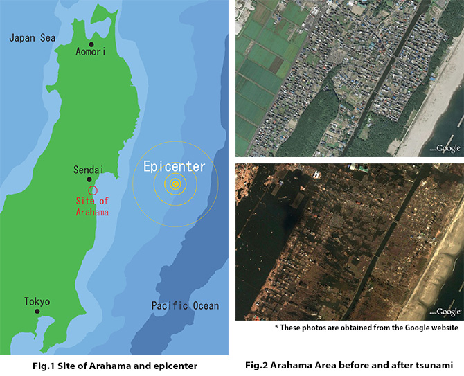
The Arahama areas of Sendai are located on the coast of Miyagi Prefecture facing the Pacific Ocean. There was a popular swimming spot crowded with many people in summer seasons, being one of the very beautiful rural scenic areas in Sendai. Many low-rise housing had been built in the rural residential area, surrounded by agricultural fields (paddies) growing rice. An awful disaster has occurred in northeast Japan on March 11, 2011. This news had been broadcast all over world simultaneously. The population was about 2,700 people with 800 households before the tsunami. The Arahama area of Sendai is located almost at the same latitude as the epicenter and is about 10 km southeast from the city center of Sendai (See Fig.1). Unfortunately this place has been introduced by Japanese media as one of the most intensely damaged areas in northeast Japan due to the last tsunami. Top picture in Fig. 2 shows the original condition of Arahama area before disaster while bottom is the completely damaged condition due to tsunami. Tsunami 9.38 m high hit the Arahama area and entered inland by about 4 km. The inundated area totaled at about 13 k㎡. Hundreds of tsunami victims were found on this coast and almost all houses near the shore line up to a distance of 4 km had been destroyed.
We therefore suggest applying the present methodology for reconstruction known as the so-called "Coastal Aqua-Village System" (See Fig.3) to the tsunami-devastated coastal area of northeast Japan. The plan is to change the potential danger in this site to produce an area safeguarded against storm surge due to huge typhoons and massive tsunamis. Fig. 4① shows a typical dangerous situation of housings on coastal area before. As is known most areas around there have sunk about 40 to 80 cm from the original ground level by huge earthquake March 11, 2011. It is almost impossible to add soils until the previous ground level is reached because too much area has been widely sunk at the same time. Therefore, the objective of this system is to introduce a waterfront development for villages in coastal zone of the Arahama area, where the social infrastructure is built on floating foundations that will not submerge due to any rise in the water level; that provides for a safe and comfortable living environment.
![Construction scheme of [Aqua-Village System]](../images/projects/photo10.jpg)
![New concept of [Aqua-Village System] in coastal area](../images/projects/photo11.jpg)
In this concept, this dangerous coastal zone area is excavated to a depth of 3 to 5m and the topsoil removed. The topsoil removed from the site is to be relocated in order to construct banks in other areas of the seaside site to protect against a run-up of seawater due to storm surge and/or high waves. To be precise, the lost residential area of approximately 450,000 sq. m is excavated and the resulting soil of 1,800 thousand cu. m is used to construct higher banks which surround the artificial water area. Next, these are filled with water including saltwater until the water level reaches sea level, to construct a man-made lagoon and/or inlet. Finally, the floating platforms made of lower cost materials such as lightweight concrete are constructed with housings and even rice paddies/agricultural fields located on floating platforms inside the man-made lagoon and/or inlet. The floating structure system consists of two elements, one is the box-type structural frames used for public roads and the other is the floating platforms where low-rise housings and/or agricultural fields are built on. Both are bound together with each other rigidly using steel connectors and are supported on concrete piles. In principle, the floating platform as well as structural frame floats by itself also but the proposal calls for what is known as a "Soft Landed System." When there is an unexpected increase in water level due to the high tide and/or the floodwater from storm surge, tsunamis and so on, the floating platform can easily change its position up from the soft landed condition. In addition, the another tall concrete piles with guide rails of 20m high are also constructed and connected with the concrete frames for the unexpected extraordinary vertical excursion of floating structures due to huge tsunami and so on.
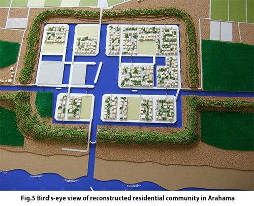
In this concept, this dangerous coastal zone area is excavated to a depth of 3 to 5m and the topsoil removed (See Fig.4). The topsoil removed from the site is to be relocated in order to construct banks in other areas of the seaside site to protect against a run-up of seawater due to storm surge and/or high waves. To be precise, the lost residential area of approximately 450,000 ㎡ is excavated and the resulting soil of 1,800 thousand ? is used to construct higher banks which surround the artificial water area (See Fig.4②). Next, these are filled with water including saltwater until the water level reaches sea level, to construct a man-made lagoon and/or inlet (See Fig.4③). Finally, the floating platforms made of lower cost materials such as lightweight concrete are constructed with housings and even rice paddies/agricultural fields located on floating platforms inside the man-made lagoon and/or inlet. The floating structure system consists of two elements, one is the box-type structural frames used for public roads and the other is the floating platforms where low-rise housings and/or agricultural fields are built on. Both are bound together with each other rigidly using steel connectors and are supported on concrete piles (See Fig.5).
In principle, the floating platform as well as structural frame floats by itself also but the proposal calls for what is known as a "Soft Landing System." When there is an unexpected increase in water level due to the high tide and/or the floodwater from storm surge, tsunamis and so on, the floating platform can easily change its position up from the soft landed condition. In addition, the another tall concrete piles with guide rails of 20m high are also constructed and connected with the concrete frames for the unexpected extraordinary vertical excursion of floating structures due to huge tsunami and so on (See Fig.6).
![Schematic elevation view of [Soft-landing System]](../images/projects/photo13.jpg)